Dhaulagiri Trekking
A circuit of Dhaulagiri massif is possible for well-equipped and fully self-sufficient parties. The minimum time that should be allowed for this itinerary is eighteen days Pokhara to Pokhara but a few extra days to allow for side trips or bad weather are advisable. The route crosses two high which are in remote country far from any assistance. Particular care must be taken with regards to proper acclimatization and staff equipment. Since much of the first half of the trek travels on rarely trekked trails, the services of an experienced local guide are highly recommended. No special permits are required for the Dhaulagiri circuit but for the last part, down the kali Gandaki, an ACAP entry permit is needed.
The trek is best started at Beni, the district headquarters of Myagdi district. Myagdi is one of the most easterly of the districts where the Magar people can be found. This group of hill dwellers are similar in many ways to their Gurung neighbors but are thought to have settled in Nepal some time earlier. Like their Gurung cousins, the Magar have a tradition of service in the Gurkha regiments. Regular bus services operate from Pokhara as far as Baglung and from there, are less frequent services to Beni.
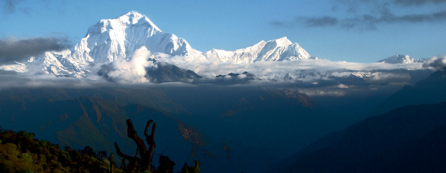
The Dhaulagiri trail follows the Myagdi khola, the river that drains the southern side of the Dhaulagiri massif. Passing through the settlements of Darbang and Muri, the country is still quite heavily populated with scattered villages and farming land. Beyond Muri, the Myagdi khola swings north and the landscape becomes much more rugged and sparsely populated. The tree line is reached just below the sit of the, so called, Italian base camp, located at the snout of the Chhonbaraan Glacier, is an ideal place to spend an acclimatization day exploring the hills around about.
The next two days are spent on the glacier, the second night being at Dhaulagiri base camp, a rugged spot with some spectacular views of the western face of Dhaulagiri.
From here the trial crosses French pass which at 5360 meters is the highest point of the trek. Descending French pass you enter the lonely but fascinating area known as Hidden valley. This place is one of the few true wilderness areas accessible to trekkers in Nepal. The valley stretches away to the north eventually narrowing to a rugged gorge that connects to Upper Dolpa. There are reports of many endangered species residing in this area including the elusive snow leopard. If all the members and the staff of the group are fit then a rest and exploration day spent in hidden valley is well worth while.
From Hidden valley the trial now crosses Dhampus pass (sometimes known as Thapa pass). While not as high as French pass, it is roughly 100 meters lower, Dhampus pass has a reputation for bad weather which can make the crossing and subsequent descent something of a problem. Trekkers must be aware of the health of their group members and staff, especially on the section between French pass and Dhampus pass. Any person suffering from the symptoms of AMS must never be taken on over French pass but rather, taken back down the Myagdi khola to a lower altitude. Having a group member suffer from AMS between the passes poses a serious problem as the only way to get the patient assistance is to ascend which would make the problem worse.
Having crossed Dhampus pass the trial descends into the valley of the kali Gandaki meeting the main trial at either Marpha or Tukuche. On the way down to the valley there are some spectacular views across to the Annapurnas and up into the arid steppes of Mustang.